Measure Ground Control is a SSoT for flight records, mission planning, and maintenance of UAS. An SSoT is defined as a single source of technology solution. Measure Ground Control was developed with the help of commercial drone operators with the purpose of being the most complete software program for drones. The application itself has a copious amount of useful features.
Measure Ground Control is capable of:
- creating and scheduling missions
- assigning pilots and equipment for missions
- creating a grid or way point flight plans
- making one aware of airspace and weather conditions
- requesting LAANC authorization
- flying GPS aided manual controls
- using track modes
- automatically uploading flight logs
- storing unlimited imagery and flight logs
- accessing flight playback
- automatically flagging incidents
- managing equipment
- automatically tracking equipment usage
This SSoT is extremely efficient because it rids the need of using multiple applications at once. It can be easy to become unorganized and distraught during a UAS operation while switching between multiple apps and platforms. (At least it is for an amateur like myself.) This SSoT is also useful for mission planning and organization because it allows you to schedule as well as keep a calendar for missions. The ability to automatically update flight logs with great accuracy is also a perk when it comes to organization.
There are also an immense amount of safety features available through this SSoT. The ability to make phone calls to ATC through the app as well as request LAANC authorization is an incredibly useful feature for flight authorization. The ability to track equipment usage is also useful because it allows one to set a time window for when maintenance may be necessary. Accessing flight playback can be beneficial in regards to safety because it allows for pilots to determine errors in judgement that may have lead up to flight incidents or crashes. It almost goes without saying that the ability to determine weather anomalies and airspace requirements is also integral to maintaining safe UAS operation.
Within this lab I will explore the mobile and desktop features of Measure Ground Control. I will use this application in order to determine airspace requirements, plan a mission, and explore the fly screen.
Methods:

(Figure 1: Purdue Wildlife Area Location)
The first thing I did before diving into the app was find the exact location/ address for the Purdue Wildlife Area. I participated in a lab for AT 309 at this location, so I believed it to be outside of class Delta airspace. I wanted to ensure this information was accurate, and the Purdue Wildlife Area is in fact in uncontrolled airspace. In this area normal CFR 14 Part 107 rules apply. The ceiling for the class G airspace could be 700-1200 ft AGL, but one would never legally reach this ceiling figure 2 below shows the class delta relative to an estimated location of the Purdue Wildlife Area. I later verified this again within the mission planning section of the application by inputting the address of the location. This can be seen in figure 3 below.

(Figure 2: Approximate Purdue Wildlife Area Location)

(Figure 3: Verification that the area is outside of class D airspace)
After verifying the airspace regulations for the Purdue Wildlife Area I decided to do the same for Martell Forest. The location for Martell Forest can be seen below in figure 4. Although the pin for Martell forest appears to be outside of the class Delta; it is hard to tell where the forest stops and ends. In order to be safe in this situation I would recommend recording GPS or ground control point locations in order to verify the mission will not take place within the class delta. If it is necessary for the mission to take place within classified airspace; one may have to acquire a waiver from the FAA and clear the flight with ATC. Requirements for airspace around this area can be seen in figure 6. Within the map section of the application it is also possible to view airspace advisories. These advisories can be seen in figures 7 and 8.

(Figure 4 location of Martell Forest)

(Figure 5 possibility that Martell may extend into classified airspace)

(Figure 6 airspace information)

(Figure 7 Airspace Advisories)

(Figure 8 Airspace Advisories)
Figure 9 below shows the fly screen display on the mobile application. The fly screen is useful because the large amount of features rid the need for the use of multiple apps in order to do things like adjust gimbal and camera settings. This screen is used for pre determined flight plans or GPS assisted manual flight.
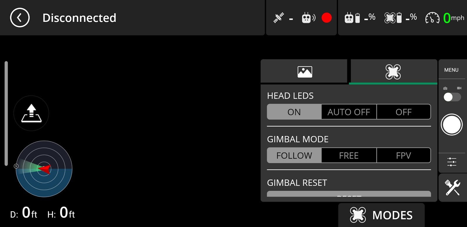
(figure 9 flight screen display)
Figure 10 shown below displays the flight planning section of the mobile application. I chose to plan a grid flight pattern over the Purdue Wildlife Area. You can search for previous flight plan which can save time and create consistent results when operating in the same area. I also explored the mission planning section of the application which is incredibly useful for organizing missions because it allows you to do things like schedule the mission, clear the flight, organize equipment and assign pilots all in one page. There is also a terrain option within the flight planning screen. This setting is useful for safety because it allows for the drone to make slight adjustments to its altitude based off of the terrain that it is flying over.

(figure 10: flight planning screen)
Conclusion:
After completing this lab activity I am convinced that Measure Ground Control SSoT is an incredibly useful and efficient tool for commercial UAS operation. I believe what sets this application apart from others is the strong emphasis on safety and mission planning in combination with the features available through the flight screen. I believe that an SSoT application like this is beneficial because it allows UAS operators to work through one application at a time. I'm interested in actually using this application for flight in the future.